
The Complete Guide to Running The San Juan Trail in Orange County
In training for and tracking workouts for triathlons and general fitness, one of the most enjoyable activities I have found is a long trail run up a mountain. In Orange County there are a handful of trails that scratch that itch, including one that is known to mountain bikers and hikers, the San Juan trail. The trail is a popular mountain biking spot, but also is ideal for a long path that is well maintained but relatively lightly traveled.
What is the San Juan Trail?
The San Juan Trail is a hiking and biking trail that runs through the Cleveland National Forest in South Orange County California. It runs from Bluejay Campground, a beautiful first come first serve campsite that sits at around 3300 feet above sea level, down to the Hotsprings trail head, which sits at just 800 feet above sea level.
From the bottom the trail begins in a small grove in a valley and wraps switchbacks up through small rock formations, dusty ridge lines, and a small wildflower filled meadow (depending on time of year – the wild flowers get baked away in the summer heat).
At 11.6 total miles (one way) and offshoot options to add a little more, the trail is open for hikers and bikers all year round, and tends to get a decent amount of downhill bike traffic. The biking is a wonderful experience since it is uninterrupted single track, although it is technical enough and long enough to deter many riders.
How to Get To the San Juan Trail Head
There are two ways to approach the San Juan trail, from the bottom or top, but both are accessed off of Ortega Highway (highway 73) which cuts from San Juan Capistrano out to Lake Elsinore. Because of the distance and climbing doing a shuttle to the top and leaving one vehicle at the bottom also is a good option so it’s worth knowing about both approaches.
For the bottom of the trail it is easiest to drop in the address (18-16 Hot Spring Canyon Rd, California) to Google maps. The site is noted as both the Hot Springs Trail Head, and the San Juan Trail parking. All of this is accessible off Ortega Highway, you need to look for Hot Springs Canyon Road. The turn off is right next to the Forest Fire Station.
The road itself is drivable, but in rough shape so although it is paved it will have a flavor of an fire road or dirt path. Beyond the parking lot, which also has a small pit style restroom, is the Lazy W camp. This is a church run camp and is the only other destination past the parking lot so if you see the entrance of the camp you have gone too far. The camp is also signed from Ortega, so look for those as you are approaching. If coming from the West (near San Juan) it is easy to see the turn off and signs off to the left.
How to Prepare for Running Up the San Juan Trail?
As far as trails go, the San Juan trail is both technical and hilly. Portions of it include roots, rock features, and loose dirt so having good footing is important. The trail also contains significant sun exposure and, since a round trip can be almost 18 miles, that is a long time to be out there.
There are segments of the trail that average nearly a 10% grade over 3 miles. Keep this in mind, anyone who is not accustomed to climbing or descending is bound to get beat up over this section. Many runners will approach uphill sections with a power hike, or run/walk combo, and for all but the most intense runners this is highly recommended.
If you have not been on a long run of 12+ miles that climbs at least 1000-1500 feet, it would be wise not to try to do an out and back on the trail. Portions of the path are remote enough to not get much cell phone reception, and even though the trail is popular, it is possible to spend an hour or more on it without passing anyone in either direction.
The Best Gear You Need To Bring Along on a Hiking or Running Trip Up The San Juan Trail
Before getting on the trail making sure you have the right gear to support is important as well. With the potential to be out on a run for 3-6 hours, and away from quick access to normal amenities, a small but versatile pack is helpful. If you can find a
The best gear you need for hiking or running on the San Juan Trail includes:
- A hydration pack: Choose your size accordingly but know that there is no place to refill along the route. Although there are bathrooms at the upper and lower trail heads, potable water to refill is not available.
- Phone or GPS: The trail is well established and route finding is not difficult, however there are a handful of small turnoffs that can easily cause confusion especially when tired or in a zone. Trail maps are helpful, but unless you are adept at route finding there is no replacement for a GPS based device that will remove all doubt on where you are.
- Nutrition: As with any multi-hour run or hike having enough calories is helpful to avoid fatigue. Make sure that the sodium content in some of the foods is also sufficient as the area is exposed and you are likely to be sweating substantially even in some of the colder months (since even those can get warm in Southern California)
- Sunscreen: Seriously, the place is exposed. Although if you run in the morning a good chunk of the run will be shaded by the hills, there is a good chance you are out on exposed dirt and rock terrain for at least an hour at a time.
- Treking Poles (Optional): The trail does become steep enough to warrant poles if you are used to them. Especially if you are doing the round trip starting from the upper trail head, the climb out after running downhill for 8-9 miles can be a slog. There is no footing that really needs them, but on tired legs it is nice to be able to take some of the burden off the lower body even for a few minutes.
- A hat: Again here for sun protection, good sun hat is critical.
- Knowledge of Wildlife: There are mountain lions known to be in the area, as well as foxes, coyotes, rattlesnakes, tarantulas, deer, and insects. None of these (other than the mountain lion) pose too much of a risk if you are paying attention and making enough noise, but you better know how to handle them.
What is the Distance Up The San Juan Trail?
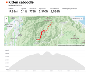
The official distance according to USDA is 11.6 miles, but the last time I ran the round trip it only totaled 17.8 miles round trip (similar to the Strava segment shown above). The variation on this is likely due to the lollipop loop near the upper trail head that provides option on the path. AllTrails has the same path at around 19.4 miles round trip, including a bit of the lollipop loop. Even so, personal experience says that it is no where close to 23 miles on a round trip so the USDA site must be including some additional distance. Even if walking across the Blue Jay Campground at the summit it still would not approach this distance.
My estimate, based off multiple runs and hikes up the trail, is to account for a 9 miles with a total of 3000 feet of vertical going from the lower San Juan trail head up to the Upper trail head where it hits Blue Jay campground.
What Else Is Near the San Juan Trail?
There are a handful of other trails that start and end near the trail heads, but after a 19 mile effort you are likely looking for something else to do. One of the more popular spots, and really the only food option near the upper trail head, is the Candy Store.
As of February 2022 the Ortega Oaks Candy store is closed. According to their Facebook post a new iteration (under new ownership) of the store is slated to open in March. If it is closed the next closest spot is headed out Ortega towards Lake Elsinore for the Hafey Farms Store and Beer Garden, this is a solid option for grabbing a bite after a day on the trail.
If you are leaving the trails and going back toward San Juan, the closest stops are at the Sendero Marketplace on Antonio and Ortega highway in Rancho Mission Viejo. There is an In and Out Burger, sub and juice shops, as well as bagels, coffee, and a full Gelson’s market that will satisfy most of the post hike or run cravings.