Want to answer the question “How Far Did I Run” or plan out a new route for a run, walk, or hike. If so you have likely found On The Go Map or other similar services. The idea behind these types of app is that you should be able to just click points on Google maps and have the distance added up.
To take things one step further OnTheGoMap automatically connects the two points using, typically, the shortest path. We have reviewed a handful of route planning tools, to see them all you can checkout our Best Apps and Tools for creating a running route or ride route. For the simplicity and performance of On The Go Map should be considered as one of the best options for finding out out how far you ran.
The app itself does not have a mobile app for iOS or Android. Instead you can use the web version natively in a mobile browser. Just navigate over to the OnTheGoMap site and you can tap away creating a route. It is somewhat nice to avoid having an app just for this simple task, although if you want the home screen shortcut it’s easy enough to just save a bookmark to the site.
Picking The Best Route With OnTheGoMap
A short coming of OnTheGoMap is that you still need to have some understanding of where you prefer your route to go. When creating a new route in an area the app will default to connecting shortest routes and does not have a lot of settings for when to prefer a different surface or type of run. While you may want to take a route that avoids cross walks, stop lights, or other obstacles that could break up a ride or run there is no great way to set that as a preference within OnTheGoMap.

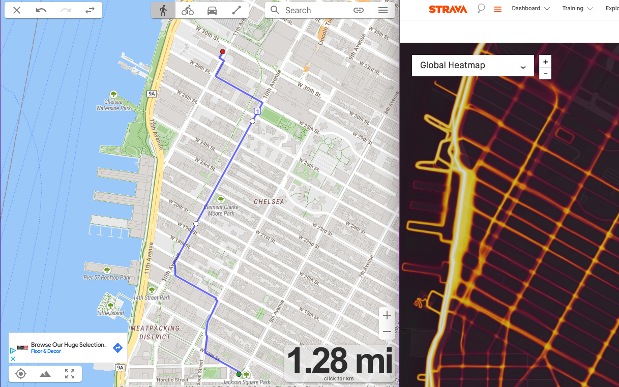
As an example of this, OnTheGoMap has no understanding of a heat map or desired preference. The above image shows a side by side of a route created with OnTheGoMap and the activity heat map from Strava. This path through NYC for a running goes very near the famous High line. Although the High line may not be great for a run during busy days, it is clear that many users prefer to use it over nearby streets, likely because it is an uninterrupted route. OnTheGoMap is at the mercy of where you click to connect points so if you click on the streets in between it will have no way of suggesting to you that your path is nearly identical to a world famous path like the High Line.
Get an Accurate Route with OnTheGoMap
When using a route planner it makes sense to wonder, Is OnTheGoMap accurate. In short, yes the route finding tool is highly accurate for anything beyond 0.1 miles, at least for finding distance. One issue with the accuracy though is knowing how well the map itself matches the underlying trail or path, especially at path intersections. Path following is what makes OnTheGoMap better than just clicking randomly on Google maps, but sometimes you need to manually override it in order to ensure accuracy.
OnTheGoMap does take into consideration the accessibility of each path though to various activity types, so trying to get a biking route vs. a running route might result in two different routes. When creating a route or mapping a previous activity to check the distance of your run, the most important thing is to pay attention and ensure that the automatically created route is realistic.
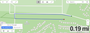
Based on the quality of the trail, road, and path data in your area there may be some major gaps. Often an issue will arise where two adjacent paths are not formally connected in the mapping data so the default path generated winds up being a very round about connection where in real life it may just mean cross a 2 foot grassy median. In the image above a path that connects and two points that are within 10 feet of each other winds up routing to a total of 0.2 miles.
When the long way around is substantially further this can create huge shifts in the total distance. For route planning this is often not an issue, as you can just keep going, but when tracking a route already run to find the distance of a ride or run it can easily add distance to a total.