Google maps and Apple maps can be good for getting driving directions, but when planning a workout you often need more details. If you are running in a new town or park then driving directions with their efficient point to point navigation are a terrible way to plan out a run. Not only is it hard enough to get walking directions where you may have to stop every block for a cross walk, but trying to plan for a flat (or hilly) run can be a pain.
This article looks at some of the options we prefer when going to plan a new route. Before setting off in a new area it can be nice to have some idea of where you are running and if it is a safe and enjoyable path. Beyond this there are a few things to consider when choosing an app to plan a running route.
- Do you have a preference of trail or road surface to run on?
- Will you need an elevation profile for your route?
- Are you looking to expand your typical running routes or planning to stay on trails that are popular (and appear on heat maps a lot)?
- Is your run going to be an out-and-back or do you prefer loops? Some tools allow for an easy out-and-back creation
- What distance are you planning to run and do you need a time estimate for completion?
- Do you need a GPS track that you can load to a watch or phone?
Once you answer these you can start to understand the actual features of a route planner that you are looking for in a route planner. Even with these though remember that all route planners are dependent on the quality of the underlying map data. If a tool is using an outdated set of maps or an old integration it may not know about new construction, changes in trails, or be able to connect paths that really are connected. Consider first if you should look for a local guide, similar to our Guide to Runs in West LA and UCLA.
When planning a route especially in a park or managed land area the best thing to do is contact the park system or trail managers directly to find out what their insight is. This helps avoid a situation where you realize that that easy path home got washed out in a rain storm and suddenly you are adding hours to your planned activity! With that, let’s take at look at some of the common running and cycling route planning tools:
Compare the Best Running Route Planning Apps
As mentioned above there are dozens of possible tools for planning a route. Each has it’s own benefits. Below we have rated some of the more popular running route planner tools.
| App | Ease of Use (1-5) | Accuracy of Maps (1-3) | Export Ability (Yes/No) | Cost ($$$) | Notes | Overall |
| OnTheGoMap | 5 | 5 | Yes | Free | 5 | |
| AllTrails | 3 | 5 | Yes (Paid Tier) | $37 (annual) | Account Required | 4 |
| PlotARoute | 4 | 5 | Yes (Paid Tier) | $25 (annual) | 3 | |
| GMaps Pedometer | 4 | 4 | Yes (buggy) | Free | 3 | |
| MapMyRun | 3 | 4 | Yes (Paid Tier) | $30 (annual) | Account Required | 3 |
| Strava (Route Builder) | 3 | 5 | Yes (Paid Tier) | $80 (annual) | Has popularity heatmaps | 3 |
| MapOMeter | 4 | 5 | Yes | Free | 3 |
Ease of Use (1-5) – Comparing general overview of how tedious it is to create a moderate complexity run in a new area. Do maps snap to route, know how to follow common turns, make it easy to undo when clicking the wrong thing, etc.
Accuracy of Maps (1-3) – Mentioned in individual reviews, sometimes maps miss out on major areas. Most tools tie back to one of the major mapping tools so many rate the same on this but we downgrade those that have more issues.
Export Ability (Yes/No)– Can you export a planned route to any popular GPS watches or tools to enable route following
Cost ($$$) – Free tools typically are ad supported, while more expensive ones might be bundled with other services. The cost is for the lowest level way to access planning tools.
Overall – A combination of everything and our subjective opinion of how good it is.
Gmaps Pedometer vs OnTheGoMap
For us these two systems work interchangeably. Gmaps Pedometer has been around for longer and has a slightly outdated UI, but both OntheGoMap and Gmaps use the same underlying mapping data. Each makes it easy to just drop a way point and allows the shortest route finder between the two to connect the dots using known trails and roads. After a lot of review we prefer OnTheGoMap, to see why you can also see our full OnTheGoMap review for finding out “How Far Did I Run”.
This still requires some local knowledge of the area if you want to choose the best routes, but that can be done by having a second tab open with a heat map.
![]()
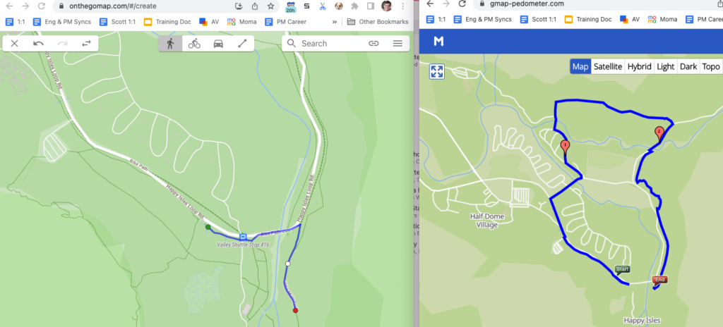
The other major issue, with both services, is when you are mapping a route that jumps between adjacent trails or surfaces. It is location dependent but there are times when the map will jump you a very long distance rather than knowing that you can cross a 10 foot grass media between the two. An example of this is shown in the comparison below where a very well established trail in a known trail system (Yosemite National Park) somehow can not figure out how to get from a bus stop to the name of the trail the bus stop is named for.
Both of these options do a good job however of telling distance. The other thing they do is provide an elevation profile for the route. This is critical, especially if you are intentionally planning hill climbing routes and tracking elevation gain. They also offer the ability to actually determine what the starting elevation and high point is for the run. This makes a huge difference since there are serious effects of altitude on heart rate and other metrics typically tracked for a workout.
Strava Routes and MapMyRun For Route Planning
Most of the major activity tracking apps have an option that allows you to plan a route. Each includes their own sets of customization options like the ability to instantly create an out and back. When looking at just Strava vs. MapMyRun, Strava tucks the route planned behind their Strava Premium subscription while MapMyRun keeps theirs included in the free tier.
![]()
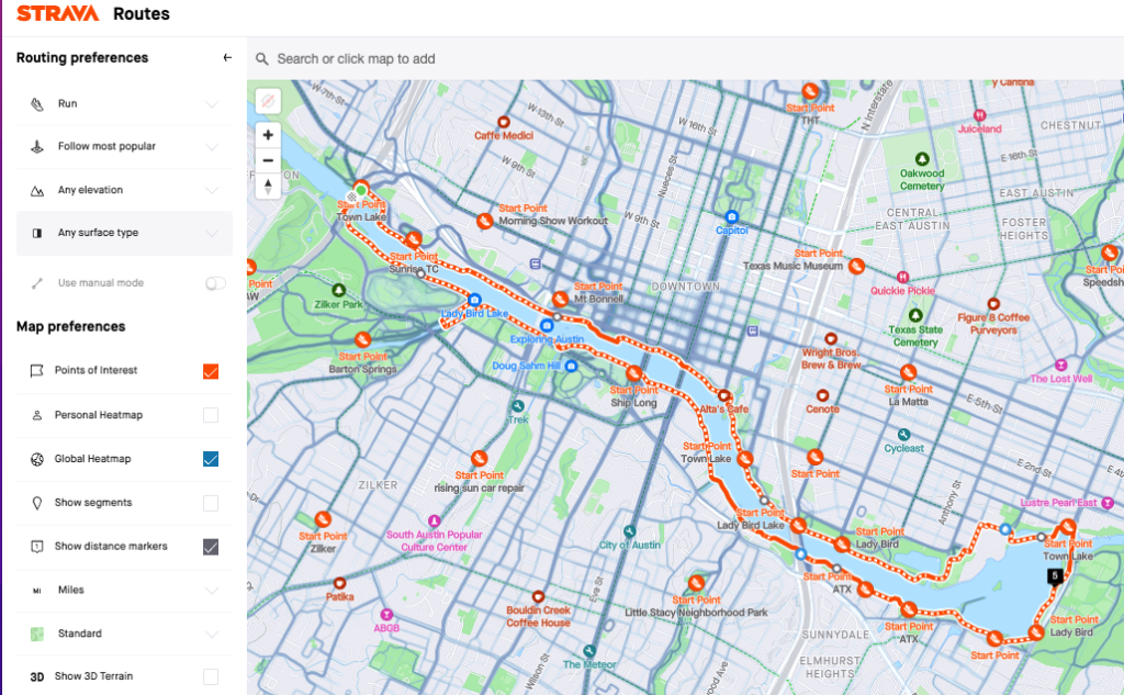
Strava packs in significantly more features and allows you to better plan a running route that matches what you are training for. For starters it allows you to find a starting point, based on where many runners begin their activities. While this does not ensure a parking lot or trail head, it does often correspond to an easy place logistically to get to for beginning a run. It also allows you to overlay a heat map directly to snap to popular paths. At the same time you can try to optimize for surface types, road or trails, and dial in elevation if you are planning a route with the intention of doing hill training.
![]()
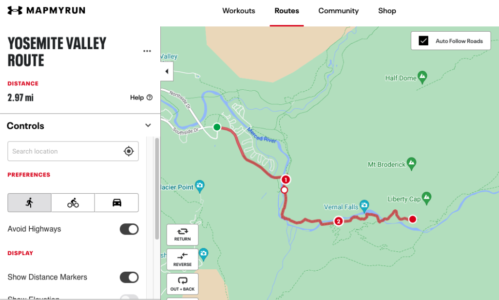
MapMyRun on the other hand most closely resembles the earlier Gmaps and OnTheGoMap options for route planning. While it does allow some customization it feels more like driving directions. Still you have the simple ability to click on the next point to ensure you are not running the most efficient location. At the same time when trying out the route planner for MapMyRun we found multiple instances where it did not have the map data for popular paths (for example in the above Yosemite picture where it thinks a widely popular portion of the Mist trail does not exist).
Social Apps for Trail Research
There are also dedicated apps that focus on researching new trails and paths. The two popular ones we have covered here are Trail Forks and AllTrails. Each of these includes some type of social media post features and user generated reviews and updates that often are better at keeping real time information about trails.
We reviewed all the best features of AllTrails in an independent review, but as a summary this app is great for discovering new trail systems that are nearby. Trailsforks is sometimes considered to be more popular than AllTrails, although it is tough to find exact detail on this. We have found that depending on your area the best option may change, so check them both out. Our Trail Forks review covers it’s best features and compares Alltrails vs. Trail Forks.
Running Routes with Apple Maps
![]()
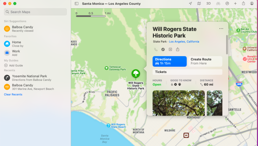
Apple Maps does not do a great job when it comes to creating any sort of routes. You can create directions, but they are clearly focused on driving and staying on roads even when selecting the walking option. This means that you will not be able to get great running route directions from Apple Maps, but the best option if you want to use a walking route is to follow the directions on how to plan a route via a mac and then share it out to another device. If you are just using an iPhone and the built in Apple maps there is no way to customize a route to ensure your running preferences are taken into account.
Google maps and Apple maps can be good for getting driving directions, but when planning a workout you often need more details. If you are running in a new town or park then driving directions with their efficient point to point navigation are a terrible way to plan out a run. Not only is it hard enough to get walking directions where you may have to stop every block for a cross walk, but trying to plan for a flat (or hilly) run can be a pain.
This article looks at some of the options we prefer when going to plan a new route. Before setting off in a new area it can be nice to have some idea of where you are running and if it is a safe and enjoyable path. Beyond this there are a few things to consider when choosing an app to plan a running route.
- Do you have a preference of trail or road surface to run on?
- Will you need an elevation profile for your route?
- Are you looking to expand your typical running routes or planning to stay on trails that are popular (and appear on heat maps a lot)?
- Is your run going to be an out-and-back or do you prefer loops? Some tools allow for an easy out-and-back creation
- What distance are you planning to run and do you need a time estimate for completion?
- Do you need a GPS track that you can load to a watch or phone?
Once you answer these you can start to understand the actual features of a route planner that you are looking for in a route planner. Even with these though remember that all route planners are dependent on the quality of the underlying map data. If a tool is using an outdated set of maps or an old integration it may not know about new construction, changes in trails, or be able to connect paths that really are connected. Consider first if you should look for a local guide, similar to our Guide to Runs in West LA and UCLA.
When planning a route especially in a park or managed land area the best thing to do is contact the park system or trail managers directly to find out what their insight is. This helps avoid a situation where you realize that that easy path home got washed out in a rain storm and suddenly you are adding hours to your planned activity! With that, let’s take at look at some of the common running and cycling route planning tools:
Gmaps Pedometer vs OnTheGoMap
For us these two systems work interchangeably. Gmaps Pedometer has been around for longer and has a slightly outdated UI, but both OntheGoMap and Gmaps use the same underlying mapping data. Each makes it easy to just drop a way point and allows the shortest route finder between the two to connect the dots using known trails and roads. After a lot of review we prefer OnTheGoMap, to see why you can also see our full OnTheGoMap review for finding out “How Far Did I Run”.
This still requires some local knowledge of the area if you want to choose the best routes, but that can be done by having a second tab open with a heat map.

The other major issue, with both services, is when you are mapping a route that jumps between adjacent trails or surfaces. It is location dependent but there are times when the map will jump you a very long distance rather than knowing that you can cross a 10 foot grass media between the two. An example of this is shown in the comparison below where a very well established trail in a known trail system (Yosemite National Park) somehow can not figure out how to get from a bus stop to the name of the trail the bus stop is named for.
Both of these options do a good job however of telling distance. The other thing they do is provide an elevation profile for the route. This is critical, especially if you are intentionally planning hill climbing routes and tracking elevation gain. They also offer the ability to actually determine what the starting elevation and high point is for the run. This makes a huge difference since there are serious effects of altitude on heart rate and other metrics typically tracked for a workout.
Strava Routes and MapMyRun For Route Planning
Most of the major activity tracking apps have an option that allows you to plan a route. Each includes their own sets of customization options like the ability to instantly create an out and back. When looking at just Strava vs. MapMyRun, Strava tucks the route planned behind their Strava Premium subscription while MapMyRun keeps theirs included in the free tier.

Strava packs in significantly more features and allows you to better plan a running route that matches what you are training for. For starters it allows you to find a starting point, based on where many runners begin their activities. While this does not ensure a parking lot or trail head, it does often correspond to an easy place logistically to get to for beginning a run. It also allows you to overlay a heat map directly to snap to popular paths. At the same time you can try to optimize for surface types, road or trails, and dial in elevation if you are planning a route with the intention of doing hill training.

MapMyRun on the other hand most closely resembles the earlier Gmaps and OnTheGoMap options for route planning. While it does allow some customization it feels more like driving directions. Still you have the simple ability to click on the next point to ensure you are not running the most efficient location. At the same time when trying out the route planner for MapMyRun we found multiple instances where it did not have the map data for popular paths (for example in the above Yosemite picture where it thinks a widely popular portion of the Mist trail does not exist).
Social Apps for Trail Research
There are also dedicated apps that focus on researching new trails and paths. The two popular ones we have covered here are Trail Forks and AllTrails. Each of these includes some type of social media post features and user generated reviews and updates that often are better at keeping real time information about trails.
We reviewed all the best features of AllTrails in an independent review, but as a summary this app is great for discovering new trail systems that are nearby. Trailsforks is sometimes considered to be more popular than AllTrails, although it is tough to find exact detail on this. We have found that depending on your area the best option may change, so check them both out. Our Trail Forks review covers it’s best features and compares Alltrails vs. Trail Forks.
Running Routes with Apple Maps

Apple Maps does not do a great job when it comes to creating any sort of routes. You can create directions, but they are clearly focused on driving and staying on roads even when selecting the walking option. This means that you will not be able to get great running route directions from Apple Maps, but the best option if you want to use a walking route is to follow the directions on how to plan a route via a mac and then share it out to another device. If you are just using an iPhone and the built in Apple maps there is no way to customize a route to ensure your running preferences are taken into account.